JGI offers unique technology packages that produce high-resolution subsurface models for a variety of applications, from oil and gas exploration to carbon storage projects.
How is your company contributing to the carbon-neutral targets, considering the agreements made at COP26 in December 2021 and the ambitious goals set by the Suga Administration for 2030? What specific technologies or solutions are you providing to assist your clients in achieving these carbon-neutral objectives?
Our core business spans about six key areas. The initial area is the Oil and Gas exploration and development area, to which we have been contributing since the beginning of our company. The technologies which we have long cultivated in those areas have been refined and applied to the various services in the carbon neutral projects. The second area involves the safety assessment of nuclear power plant sites, which is not directly related to Carbon Neutral, but is implicitly related. The third focuses on the development of resources from submarine hydrothermal deposits, rare earth mud and methane hydrate. We are actively involved in a national project to explore this area and advance technology for developing these marine resources. Fourth, we are engaged in the development of geothermal resources. As the fifth, we're committed to addressing the civil engineering, environmental preservation, and the disposal of high-level radioactive waste. Finally, we are placing special focus on services related to the CCS (Carbon dioxide Capture and Storage), one of the key technologies for mitigating global warming.
We are specifically developing technologies for CCS and CCUS (Carbon Capture, Utilization, and Storage). Over the past three to four years, we have focused on delineating subsurface structures for CCS/CCUS and monitoring time-related changes in CO2 plume behavior. Concurrently, we've made significant progress on a comprehensive technical package for the subsurface assessment required for CCS projects under ISO 27914, the international standard for land, marine, and shallow water CCS storage.
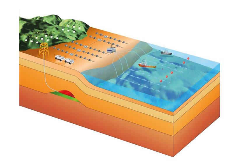
In this technology package, a geological model is developed through high-precision 2D-3D seismic surveys for site screening, followed by CCS reservoir evaluation, well design and integrity assessment of injection and observation wells, and geomechanical analysis.
In the next step, we will conduct CO2 simulations for the next 100 years and design a comprehensive and unified monitoring system.
We are aiming to initiate monitoring operations to track and identify changes in the behavior of the injected CO2. For this purpose, we have established an agile and adaptive structural exploration system, which is already in operation, and we have also built up in-house monitoring technology, including our proprietary advancements. We are witnessing significant technological advances in the CCS field, recognizing the promising potential for further development.
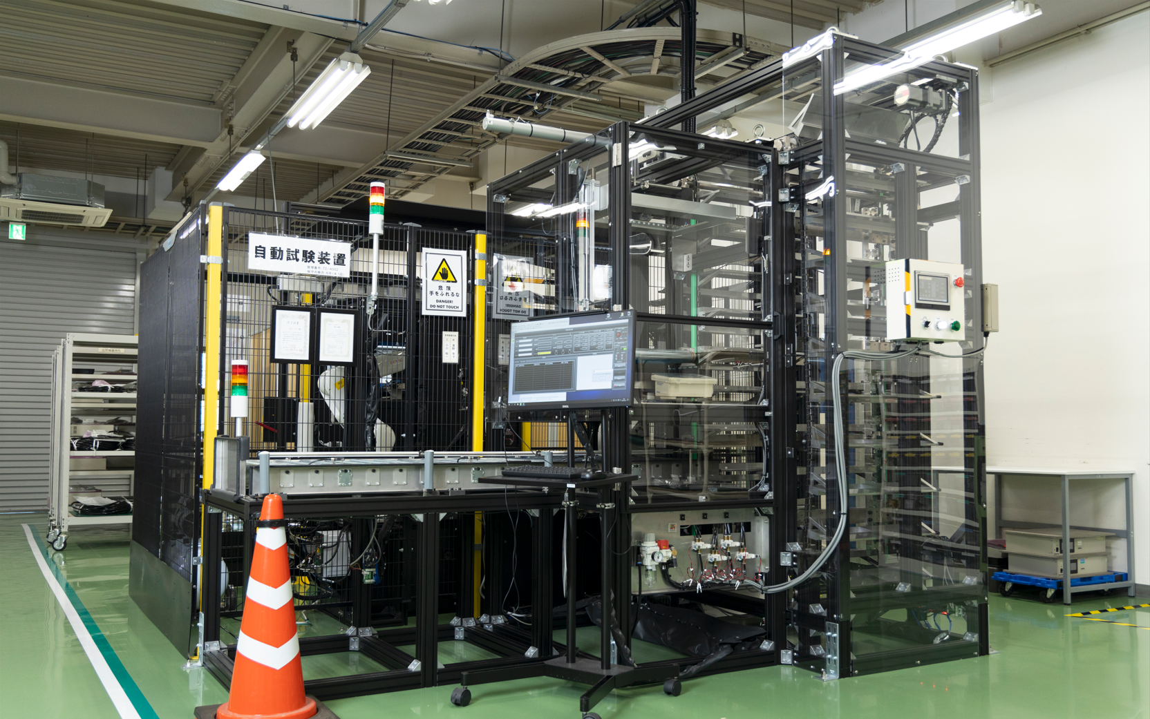
Seamless data acquisition
How does your company address the challenges posed by Japan's aging and shrinking population, particularly concerning the limited pool of talented graduates available to succeed the workforce and transfer knowledge to the next generation of scientists and engineers?
Automation is a key solution in our exploration and survey efforts. We are currently working with other organizations to explore the advancement of AUV (Automated Underwater Vehicle) technologies for offshore exploration.
Currently, our land-based seismic source vehicles, Vibroseis, are controlled by high-precision GPS signals, but within a few years, we hope to introduce automated seismic source vehicles and automated survey vessels. Our goal is to automate data acquisition in the field, alleviate manpower shortages, and ensure comprehensive data coverage.
On the geophysical data analysis side, we are actively developing technologies to automate various processes, such as the automated analysis of satellite imagery.
Could you provide more details about the method used by your company to interpret subsurface structures and analyze reservoir properties when conducting storage suitability surveys for CCS? Specifically, how does your 3D visualization technology assist in this process, and how do you monitor CO2 injections and geological information during these investigations?
The focus is not only on the method, but also on creating a highly accurate and precise geological model. This requires the acquiring sophisticated processing technology tailored to the analysis of geological survey data, particularly for the evaluation of subsurface deposit layers. Integrating and amalgamating the collected data is critical to building a precise model.
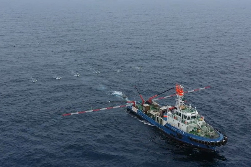 Marine Seismic Survey by HRS system
When evaluating the suitability of reservoirs for CO2 storage, what specific criteria does your company consider?
When designing the CCS site, two primary criteria come into play. Firstly, proximity to the CO2 emission source is crucial, and secondly, securing the largest feasible reservoir site. In the Japanese context, however, the priority leans toward selecting sites closer to the source of CO2 emissions rather than focusing solely on reservoir size, given the need to transport captured CO2 efficiently, possibly by ship.
Another important criterion is to locate a shallow site rather than a deep one. While deeper injection sites are more favorable for injecting CO2 in a supercritical phase, which is typically achieved at 800 to 1000 meters below the seafloor, but the cost implications of injecting CO2 into a deeper reservoir, coupled with the search for a large aquifer site are challenging. Therefore, under conditions where supercritical phase can be achieved, advances in technology to explore and evaluate larger aquifers at shallower depths are essential.
Could you provide further details about the services your company offers in supporting natural gas exploration, marine and seabed resource exploration through 3D subsurface modeling and seismic analysis? How does this support the overall supply of resources and energy? Additionally, could you highlight some key technologies your company has developed specifically for this field of service?
We offer a range of exploration technology packages that provide a variety of vertical and horizontal resolutions, depending on the depth and horizontal scale of the exploration target. For example, we are advancing multi-scale seismic technologies, including conventional 3D seismic surveys, high-resolution 3D seismic surveys, and ultra-high-resolution seismic surveys. Currently, we are focusing on the deployment of ultra-high-resolution 3D survey technologies. These technologies are being used for natural gas and methane hydrate exploration, as well as for seabed geological surveys for offshore wind farms in Japan.
Meanwhile we are continuing to establish the technology for seafloor exploration technology using AUVs. Trials of ocean mineral deposit exploration utilizing AUVs and vertical cables are expected to be completed in the next few years. Although there is currently no standard for such advanced exploration technology in Japan, we aim to market this technology worldwide as a combined package of AUVs and vertical cable systems.
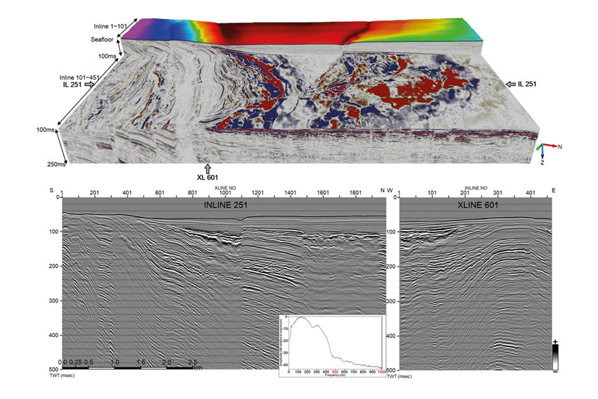
3D visualization of subsurface
Considering the absence of a standard in Japan, you're targeting foreign markets. From your perspective, which technology do you believe holds the most potential for success in these markets?
We believe that the high-resolution and efficient exploration technologies using AUVs and vertical cables, which we are currently trying to promote, are promising. Our multi-scale 3D exploration technology find application in site surveys, particularly for advanced needs in engineering and seabed risk assessment for seabed geotechnical investigations for offshore wind farms and CCS site evaluation.
Although there are many competitors in this field, we are looking to enter the Southeast Asian market. Despite receiving multiple inquiries about our technology, distinguishing our offerings remains a challenge. Hence, our focus is therefore on enhancing the value and differentiation of our technologies.
Collaboration often serves as a way to harness external expertise, fostering competitiveness and effectively communicating your technology's message in foreign markets. Your company has engaged in partnerships with institutions and organizations to develop various technologies. How integral is partnership within your business model, particularly concerning expansion into overseas markets? Are you actively seeking new partnerships in these foreign markets?
We strongly believe in the importance of partnerships when venturing into new markets. For example, when we entered the Indonesian market, we identified a local partner who played a crucial role in our success. Overseas partnerships, for us, serve the purpose of establishing a system for division of labor. Collaborating with our local partners, we can engage in joint exploration or surveys. In this collaboration, the local partner takes on the role of the field operations, handling analysis, assessment, and marketing to clients. Our ongoing challenge is to identify proficient partners with the capabilities to efficiently collect high quality data in the field.
As the company's president, what would you identify as your primary competitive advantage? What sets your company apart as a crucial partner for international collaborators?
Establishing partnerships requires a delicate balance between showcasing our advanced capabilities and technologies while protecting the confidentiality of our unique technologies. Achieving this balance is a significant challenge.
How does your company approach active fault investigations, particularly in a region like Honshu, where the intersection of tectonic plates poses a risk of natural disasters? What specific methodologies and technologies does your company utilize in these investigations? Additionally, how do geological surveys contribute to enhancing our comprehension of fault structures, thereby aiding in mitigating earthquake risks?
Our explorations have revealed geological boundaries, reaching depths of 30-50 kilometers to visualize plate structures beneath the Japanese islands through deep crustal surveys. Furthermore, we have contributed to disaster prevention planning by extracting plate asperity zones through advanced exploration and analysis technologies. Over the past 35 years, we have been contracted by the Japanese government to conduct fault delineation projects that have provided information on the basic geometry and branching of active faults. This data forms the basis of a three-dimensional geological model of Japan.
Distinguishing between engineering basement and earthquake basement is crucial for earthquake motion prediction. While most geological survey companies in Japan can only probe down to relatively shallow layers including the engineering basement, our technology can capture the entire subsurface structure, from the engineering basement to the deeper seismic basement.
The ability to predict earthquakes has been a longstanding challenge. Do you foresee a time in the near future when companies or governments might achieve the capability to predict earthquakes reliably?
Predictions related to earthquakes involve two aspects: the timing of occurrence and the potential extent of damage. Using our 3D subsurface structure model, it is possible to estimate the potential damage. However, forecasting the exact timing of an earthquake is still out of reach. Currently, there is a government forecast that the Greater Tokyo area could experience a major earthquake within the next 30 years. Therefore, knowing the extent and area of potential damage in advance is very important.
As your company commemorates its 40th anniversary this year, looking forward to the 45th anniversary, what ambitions or goals do you, as president, aspire to achieve by then? How would you envision your company being perceived within the international market at that milestone?
Over the next five years, we aim to expand the scope of our geological survey business by exploring new markets and leveraging the technologies we have developed. For example, we are considering entering the medical field by utilizing our high-precision signal analysis technology in seismic surveys. Currently, the technology for quantitative analysis to detect cancer cells and tissues has not been established, and we perceive significant potential in this area. Looking further ahead, we are also considering entering the field of space development, including lunar subsurface exploration.
How can you explain your vision with one phrase?
“Visualization of All targets”
We have been and will continue to develop and apply our technology to visualize and understand targets - everything from the Earth's subsurface to outer space, from the human body to structures.


0 COMMENTS